The malaria information system was established using the existing health infrastructure in a rural region of South Africa. This region has a high incidence of disease, a poor socioeconomic infrastructure, and one of the lowest per capita incomes in the country. It is also important to note that people do not live in villages, but in patriarchal homesteads usually separated by 50 to 500 m, depending on the terrain. This situation poses some unique issues related to malaria control.
The historical perspective of the disease is also important, as it helps to contextualize the successes achieved by the program to date. In 1932 every magisterial district within KwaZulu/Natal Province reported cases of malaria; estimated deaths over a 6-month period were in excess of 22,000 for a population at risk of 985,000 (le Sueur et al. 1993). The impact on the economy was enormous: construction of the Stanger Railway line ceased, and the sugar and tourist industries were crippled. Malaria is currently held at bay by extensive control efforts.
The numbering system is updated every second year to account for population movement and growth. Several malaria control teams are stationed in the region, and are responsible for the annual application of a residual insecticide to the wall of every structure within one or more control areas. This insecticide application constitutes the major thrust against the mosquito vector.
In addition, the teams are responsible for carrying out active surveillance, whereby the population is routinely screened for infection. Infected cases are then treated and followed up to ensure parasite clearance. In this manner, the parasite reservoir is controlled, and transmission becomes limited.
This control infrastructure has been used to establish a computerized database that includes data on every homestead in the areas of malaria control (Table 1). The database is printed every second year and updated by control program staff during their annual spraying; changes recorded are subsequently made to the existing database. In the current update, information on Chief and Induna are being collected so that the database can be related to the tribal address system.
| Table 1. Homestead database for areas under malaria control. | |
|---|---|
| Data field | Example |
| Owner | Aaron Siyaya |
| Area | Mamfene |
| Section | 8 |
| Homestead number | 145 |
| Population | 12 |
| Bed bugs present | Yes/no |
| Insecticide used | DDT/FICAM/CYFLUTHRIN |
| Longitude | 28° 12' 43 2" S |
| Latitude | 30° 58' 39 7" E |
| Wall surface | 3 1 0 0 1 |
The database contains information on the head of the homestead, his "malaria home number," the type of structure, and the population living on the homestead. A set of GPS coordinates is subsequently added using a handheld GPS. Position is accurate to 50 m, with a 95% confidence limit. A year was spent assessing the suitability of three different units in terms of accuracy, robustness, battery consumption, portability, and ease of use.
During the collection of homestead position data, information on clinic and school attendance was also collected. Table 2 shows the database format in which every malaria case is recorded. It is important to note that the malaria area, section, and house number are common to both databases, and act as a relational link between the two. It thus becomes possible to plot all cases at an area and section level; in areas where GPS coordinates have been added, it is possible to plot cases at the homestead level.
| Table 2. Malaria case incidence database. | |
|---|---|
| Data field | Example |
| Name | Velaphi Sithole |
| Case number | 581 |
| Month | January |
| Day | 22 |
| Notified district | Ubombo |
| Source district | Same |
| Notified area | Mamfene |
| Source area | Same |
| Section | 8 |
| Homestead number | 145 |
| Age | 12 |
| Sex | Male |
| Method of detection | Active/passive |
| Physiological status | Healthy/sick |
| Parasite | Trophozoite/gametocyte/Plasmodium falciparum |
As outlined earlier, current control efforts have to a degree been compromised by factors such as drug resistance, changes in vector behaviour, agricultural development, and so on. It therefore became necessary to investigate supplementary control efforts.
Le Sueur and Sharp (1988) have demonstrated the occurrence of a seasonal contraction and expansion of the malaria vector population. In winter the vector population is localized, and the larval cycle of the mosquito population increases from approximately 8 days in summer to 44 days in winter. As a result, the production of adult mosquitoes is reduced and the population is concentrated in the larval stages. If the winter sites could be located, they could be targeted for supplementary control measures, thereby enhancing overall control efforts. This was the central theory on which this project was conceptualized.
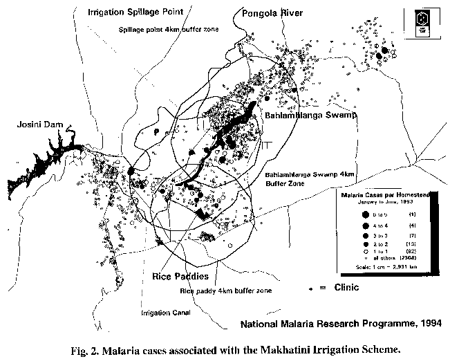
In instances when malaria cases can be pinpointed to specific coordinates, and when these coordinates can be plotted on a topographic map, control measures can often be easily determined. For example, it was discovered in the Mamfene area that a prevalence of cases was recurring at a specific geographic location (Fig. 2). It was expected that a breeding focus probably existed at that location as well. Although little could be determined from first attempts to plot the findings at a 1:250,000 scale, when these coordinates were plotted on a 1:50,000 topographic map, they coincided with a water body in the area. Thus, it was determined that this location could be targeted for environmental management, to permanently alter or remove the breeding site. This action may or may not involve the provision of an alternative water source. The long-term benefits would, however, be cost effective, when considered against the background of ongoing, long-term control costs. Digitizing of all the high-risk areas at a scale of 1:50,000 is currently in progress. Should this level of detail be insufficient, then digitizing of 1:10,000 ortho-photos will be carried out.
One example at the micro level centres on the issue of agricultural development in malarious areas. Between 1976 and 1986, the Mamfene area had an annual average of 12.6 cases of malaria. This increased to approximately 700 cases in 1987 as a result of excess water spillage due to agricultural irrigation. This spillage could have been avoided by proper planning in the development phase of the scheme, and highlights the need for intersectoral collaboration. The association between malaria cases and the scheme becomes evident when plotted on a map: mosquito flight ranges and breeding sites were affected or created by the irrigation process, and almost all malaria cases that occurred in 1987 fall within the buffers of these new ranges/sites (Fig. 2). The cases that occurred along the canal were probably associated with breeding sites formed as a result of the interruption of natural water runoff during construction, as well as leakage from cracks in the canal.
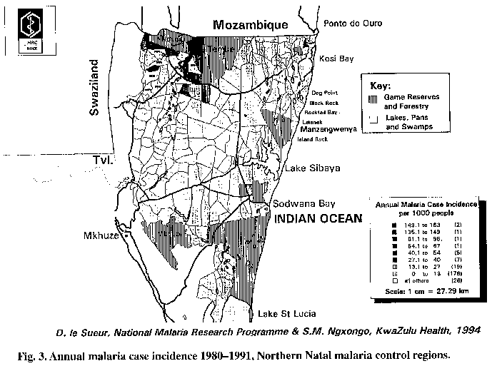
At the macro level, a map indicating the annual incidence of malaria in Ingwavuma and Ubombo between 1980 and 1991 demonstrated that cases were not evenly distributed throughout the region, but were in fact highly concentrated (Fig. 3). It is likely that within these sections there will once again be a focus relating to the proximity of vector breeding sites. Such data can play an important role in the management of a malaria control program. These two northern districts generally contribute in excess of 75% of malaria cases occurring within the province. Two important factors should be noted: the low incidence in the coastal region and the localization of high incidence to the Ndumu/Makhanisdrift area.
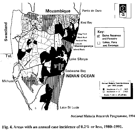
In the coastal regions (Fig. 4), the incidence of malaria is extremely low (< 0.2% per year), with many of the malaria sections reporting only one or two cases per year. The data have as yet not been divided into active and passive case detection. The almost negligible number of cases suggests that no local transmission is occurring; the cases reported are probably infected migrants entering the region.
This argument is strengthened by extensive surveys that have been conducted in the region, in which almost no vector mosquito species were found. The plotting of the actively detected cases will strengthen this argument. In 1938 the same area constituted the only region of continuous transmission in the country. This change can be largely attributed to the eradication of Anopheles funestus from the region and the fact that this vector's breeding sites are not utilised by the remaining vector, Anopheles arabiensis. Control measures do not currently exist in Mozambique, thus a need exists to continue with residual spraying to prevent the reintroduction of the former species into South Africa. Nevertheless, it can be concluded from the available data that the risk of future disease within this region is negligible. The malaria control management implications of this are discussed later.
The data do, however, have implications for tourists visiting the popular coastal region, with regard to prophylaxis. Due to chloroquine resistance within the region, tourists are required to take prophylactic medication, which varies in cost between USD 25 and 45 per course. Residents in the area do not need prophylaxis. To facilitate dissemination of such information to the public, maps are published in the newspaper showing the transmission areas for the 4 weeks prior to publishing.
Mapping of Research Findings
Maps were created showing incidence data divided into two periods: 1980-1986 and 1987-1991.
This division illustrates the recent increase in the number of cases within the area, which
can be attributed to three factors:
Many of the alternatives such as pyrethroids, however, are biodegradable and thus not as stable as DDT. As a result, their lifespan (residual efficacy) is often limited on certain surfaces; thus consideration of the material of which house walls are constructed becomes important.
To be effective, these insecticides must have a residual effect for at least 5 months. In the laboratories of the project team, trials are currently being conducted on alternative insecticides with three different substrates.
The large number of nonmud substrates in the northern regions is largely a result of the sandy nature of the soil. Grass and reeds are therefore often used in construction, and generally provide a residual lifespan in excess of nine months. These data can be used to target certain areas for cost effective, alternative insecticide applications.
Population Density
Maps showing population density are also of use. Such data are currently being used to select a
site in which bed nets (horizontal vector control) can be compared to residual spraying (vertical
vector control) in terms of efficacy and cost-effectiveness. Similarly, these data can be used in
conjunction with clinic catchment data to look at the potential for restructuring the parasite
control component such that it can be carried out horizontally at the clinic/community health
worker level.
Such investigations are essential to ensure that the restructuring of control efforts does not result in a loss of the enormous control gains made thus far, with the population within the area being placed at increased risk. This is especially important given the low levels of immunity in the population, in most areas, due to in excess of 40 years of control and consequent low levels of exposure.
The implications of such data to other sectors is obvious. There are approximately 100 malaria sectors in a district such as Ingwavuma. Data generated through the malaria information system are far more accurate than any other gathered to date, in relation to population distribution and density. Maps on the population density/km², number of structures per sector, and distribution of infrastructure (schools, clinics, shops, tribal authority, and so on) are currently being prepared for the department of economic affairs for inclusion in a proposal to the Electricity Supply Commission. In some areas, distributions can be demonstrated at the individual homestead level.
This data would be extremely valuable for the provision of primary water supply in an area. Such provision is currently complicated in the province due to the dispersed fashion in which the community lives. Thus, actual geographic distribution is important for the placement of such facilities/infrastructure and determination of the catchments they serve.
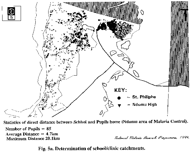
Other Uses for Maps
Maps may be used to show all houses in the Ndumu area to give a quick, accurate picture of
school catchments. Children within this area attend 14 different schools; not all are within the
Ndumu malaria area. The majority of these are primary schools, with only a single high school.
A map may, for example (Fig. 5a), show the homes of all
pupils attending Ndumu High and St
Philliphs (primary school).
Distance calculations (straight line) would show that the average pupil in the Ndumu area, attending Ndumu High, travels 4.7 km each way to school, every day. One pupil lived 20.1 km from the school. It is assumed that the pupil would be boarding with friends. This information has to be considered in light of the poor transport infrastructure within the region, as well as the extremely low per capita income to pay for such transport.
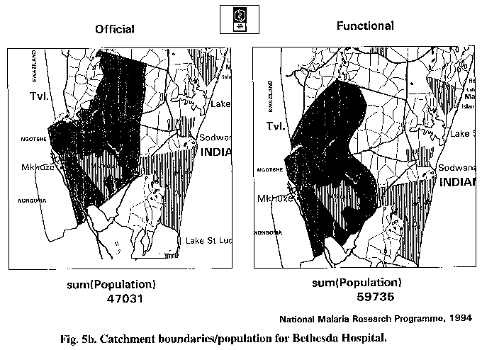
By overlaying the MIS population data with catchment areas of local hospitals, it was also possible to get a measure of the actual population that the hospital was serving as opposed to what it was officially supposed to serve (Fig. 5b). Such data, when combined with population distribution/density, are useful in planning projected resource needs and the distribution/requirement for satellite clinic facilities.
The number of imported cases of malaria per annum could also be presented in map form. It was discovered that between 1980 and 1991, the two main entry points into the country were Mbangweni corridor (between Ndumu and Tembe Game Reserves) and the Musi area.
It is interesting to note that the high level of imported cases in the Ndumu area coincides with this being the highest transmission area for the country. This highlights the importance of infected migrants acting as parasite carriers when entering the country.
The fact that no such correlation occurs in KwaNgwanase area supports the earlier conclusion that vectors are largely absent from this region and thus transmission from migrants to locals does not occur.
Incidence of Malaria
The low incidence of malaria in coastal areas reflects very low transmission rates, and the high
incidence in Ndumu, Makanis and other surrounding areas a high transmission rate. Malaria
surveillance agents are currently deployed throughout malarious areas.
The project has shown that:
 Back to Contents -
 To next section
This file was created 23 February 1996