 to continue...
  to get back to the list of exhibitors...
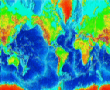
Since we can't measure everything, we are forced to resort to guessing away from data locations. For example, in weather forecasting there may be many stations which have the necessary weather monitoring equipment, but they are frequently located far from points at which one needs to know (say on top of a mountain that one wants to climb on a particular day, or at the coast).
Most people aren't too concerned about this, however, as they know that temperature is generally a slowly varying function of position - that is, if it's 70 degrees here, it's liable to be around 70 degrees not too far from here. In carrying out this reasoning process, they are in fact using experiential knowledge about the spatial statistic "mean temperature".
We (mappers, that is) can save YOU the trouble of guessing by providing a map which uses appropriate information about past weather conditions to give a better (and more reliable) estimate. And the same applies to other areas of estimation.
Click to continue... to get back to the list of exhibitors...