Chapter 7
The Fundamental Theorem of Calculus
Project 2: Area of Crater Lake
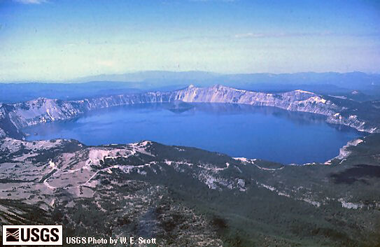
The photograph shown here is an aerial view of Crater Lake in Oregon, which is roughly circular with a diameter of about 5 miles. You can click on the photograph to pop up a page with a topographical map of Crater Lake. To answer questions a-d, you can either work with the map on your computer screen or you can print the page with the map. (A color printer is preferred but not absolutely necessary.)
- If the lake were exactly circular with a diameter of 5 miles, what would its area be? Express your answer in decimal form — this number will help you eliminate unreasonable answers when you calculate better estimates of the area.
- The grid in the map is made up of squares that are one mile on a side. By counting squares, find upper and lower bounds for the area of the lake.
- What technique might you use to get a better estimate of the area of the lake? Do it!
- Does your area estimate include or exclude Wizard Island? Explain which choice you made and why you made it.
Follow-up questions (mostly non-mathematical)
- How do you think Crater Lake got its name? What kind of crater is this?
- The map of Crater Lake is oriented as maps usually are, with North toward the top and East to the right. In what direction was the photograph taken? How can you tell? What time of day was the photograph taken? How can you tell?
- The thin red curvy lines on the map are "level lines" that indicate elevation, measured in feet above sea level. (Ignore the heavy red lines, which indicate hiking trails.) Near the shore line of the lake, those level lines are tightly bunched together, and then a little way away from the lake they spread out. What does the bunching mean? (Hint: Consult the photograph.)
- (Slightly mathematical questions) If you had to describe the 3-dimensional shape of Wizard Island in one word, what would that word be? How does this fit with your answer to part (a)? How would you describe the level lines on Wizard Island?
Want to see more of Crater Lake?
Download and install Google Earth (if it's not already on your computer). Then visit the Google Earth Community to download a KMZ file of Crater Lake and open the file in Google Earth. This will give you a 3D view that you can "fly over" and "navigate" with the on-screen controls. The KMZ file has overlays for the lake floor and the geologic structure — you can turn these on or off in the Places panel at the left of your screen. The blue dots in the picture link to pop-up pictures of other features in and near the lake.