Centre-Satellite models
You may recall that we studied compound and generalized Poisson
models using the Matui Housing data of Cliff and Ord (spatial statistics module, part I). Upton and Fingleton, in Spatial Data
Analysis by Example (p. 16) have a problem with those models:
"The compound and generalized Poisson models contain one particularly
unrealistic constraint, namely that the `offspring' are coincident with the
`parent' - in other words, they suppose that the entire cluster is situated
at a single point."
Thus we add displacement (so-called centre-satellite
models - note cool British spelling, since I stole this from those
brits):
- Parent events form a Poisson
forest
- the number of offspring generated (via some other distribution,
e.g. logarithmic)
- the locations of each offspring displaced relative to parent
according to e.g. bivariate normal. Here's an example.
"Unfortunately, the added realism of these processes results in most
intractable mathematics and none of their results seems likely to be of very
great assistance for the data analyst." Upton and Fingleton,
Spatial Data Analysis by Example, p. 17.
We show here a similar situation, although the pattern was created
in a slightly different way.
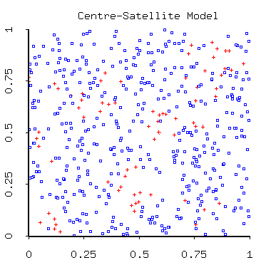 The diseased individuals are marked with the red crosses (get it?!
Sorry...), while the healthy individuals are blue boxes.
The diseased individuals are marked with the red crosses (get it?!
Sorry...), while the healthy individuals are blue boxes.
This example was created as follows:
- a set of "susceptible" points was simulated randomly on the unit square;
- another set of "infected" points was added;
- each infected individual infects a group of susceptible neighbors, the
number infected distributed as a Poisson variable - but only neighbors
within a radius of .1 units of the infected point. (If there were not
enough neighbors within that radius, all available were infected, but no
more).
Thus we might expect to see spatial autocorrelation at a scale of about .1
units.
Below is the isotropic sample variogram, plotted with a model:
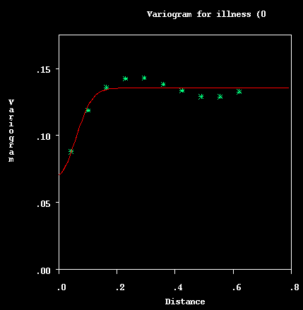
It is a "nested" model (that
is, a positive linear combination of valid models). The model is
composed of
- a nugget of about .071
- a Gaussian model with a sill of about
.063 and a range of .14, and
- an exponential model with a tiny sill (.002) and range of .07.
The model was generated automatically using the UNIX version of the Geo-EAS
software package. A form of weighted least squares is used to determine a
model, which the user is then free to adjust.
This is an example of "indicator kriging": rather than rates, or some other
continuous variable, we are actually trying to estimate the probability that
someone is ill at a given location by using the binary variable of "disease
status". Here is the resulting kriged surface:
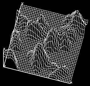 which one can use to create a contour map, representing the probability of
being diseased.
which one can use to create a contour map, representing the probability of
being diseased.
Website maintained by Andy
Long. Comments appreciated.
aelon@sph.umich.edu